- Details
- Written by: Super User
- Category: Treking
- Hits: 1234
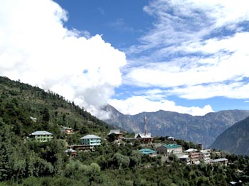
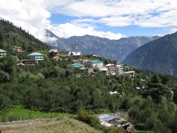
Banjar trek
This trek is very easy and very interesting trek there is beautiful mountains srounding area , temples and remote villages of Himachal Pradesh. For large distances , the trek follows the ridge line separating inner and outer Seraj.
Trip Highlights:
Total duration : 10 Nights/11 days
Grade : Easy.
Max. altitude : 2530 m/8,300ft
Best time : April-October
- Details
- Written by: Super User
- Category: Treking
- Hits: 935
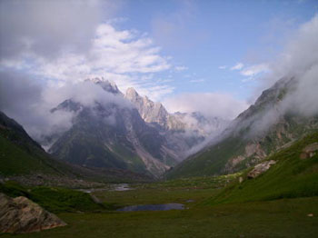
Darcha to Lamayuru Trek
Darcha to Lamayuru Trek: (Grand traverse of Zanskar)
Among the Indian Himalayan trek crossing the Zanskar valley is considered one of the major treks in north India. Zanskar remain cut off from the rest of the world for large part of the year due to snow fall which block the accessibility in to this valley hence the local use frozen river path during the winter to be connected with nearest town of Leh and the external world.
- Details
- Written by: Super User
- Category: Treking
- Hits: 1065
-
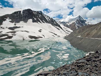
Chandertal Trek :
-
One of the most spectacular trek in Himachal Pradesh, begins from the verdant kullu valley , trail leads through dense forest and the meadows of wild flower over Hamta pass to the barren Lahoul valley , a valley dominated by massif of peaks over 6 thousands metres is a paradise for mountain climbers from all over the world.
A Chrystal clear water lake of Chandrata tal is a summer home for himalayan Shepherds, following the mountainous terrain opposite of magnificent mountain range till the scenic Baralacha la, from here you will take spectacular road back to Manali passing by scattered villages of tribal distt. of Lahoul -
Detailed Itenerary: -
DAY 01: Delhi to Manali 570 km, 16 hours.
Meet Manali volvo stand and trasfer to hotel .Afternoon we proceed to Manali local sightseen ,Hadimba devi temple , Manu Rishi temple & Vashisht Rishi temple .overnight at hotel.
DAY 2: Manali to Marsu, Saten 5 hours;
After breakfast drive to Prini village, the path leads through the village in a zigzag trail that leads to the valley floor and offers an extensive view. Now an easy path leads to the Khangpa village of Saten, the people living here have migrated from Spiti (Tibet in the olden time). The Khangpa community used to move as Nomad in Chang-Thang.overnight at camp.
DAY 3: Marsu, Saten to Balu Gyra 5 hours;
The trail begins by flat walking through the forest of Mapple, Silver Fir, Pine and Oak, paved by the grass and stone and fields of the wild flowers. Twice have to cross the river, the bank sloping down from the high cliffs all around and ideal location for the end of the day.overnight at camp
DAY 4: Balu Gyra to Shea Gahru (3700 m) over Hamta pass 6 hours;
The trail begins to ascend toward to the mighty Hamta pass and soon the distant valley of Lahoul/Spiti comes in the view. From the pass one can enjoy the view of magnificent Himalayan peaks like Deo Tibba, Indra Asan and Indra Kila. Slowly landscape starts getting rugged, one hour descend to the meadow of Shea Gahru, beautiful campsite on the foot of the glacier.overnight at camp.
DAY 5: Shea Gahru to Chhatru:
The trail descends toward the left bank of the, 'nalla'. Soon the Chandra River is in view, after 3 hours of trek reached at the beautiful campsite, after noon at leisure. overnight at camp.
DAY 6: Chhatru to Chhota Dara 5 Hours;
It is an easy walk on the dusty and rough road to the opposite side of the Chandra River between C.B. ranges and Chhota Shigri Ranges.overnight at camp.
DAY 7: Chhota Dara to Batal 5 hours;
Easy walk, once again on the same dusty road. Right of the trail opposite of the Chandra River the Bara Shigri range offers a magnificent view of the Lalana, Papsura, Dharamsura (White sale), Shangrila and many other prominent peaks of the range as well as one of the world longest glaciers. overnight at camp.
DAY 08: Batal to Chandra Tal 6 hours;
One of the most beautiful trail of the trek offers you a wonderful view of the Chandra valley as well as the now carpet mountain of the C.B range and Mul Kila. Shepherdss from the Kangra valley are with theirflocks in the valley. Visit around the valley, meet the shepherds, but be careful of the dogs. overnight at camp.
DAY 09: Chandra Tal to Topko-Yongmo (6 hours;
Very easy but a long walk with the scenery of the mountainous Chandra-Bhaga (C.B.) range on the opposite side. Camp nearby the river or just before or after crossing the river, all trekkers are advised to put on the sneakers while crossing the river.
DAY 10: Topko-Yongmo to Topko-Gongmo 4 hours;
Another river crossing is involved today, if you arrive before noon. Afternoon it is advised not to cross the river, because water level can increase rapidly due to the perpetual heat on the glacier. So one should cross as early as possible even one has to camp early day before wade through the river.overnight at camp.
DAY 11: Topko-Gongmo to Baralacha short trek;
Just crossing the river, the camp site is after two hours, near the shepherds. Pitch your tents, hot lunch will be prepared and afternoon free time to stroll around, one can study the wild flowers. over night at camp.
DAY 12: Baralacha drive to Manali over Rohtang la (3980 m)
Scenic drive through several villages of Lahoul; Passport required for checking at Koksar. Snake curved road to the Rohtang pass (3950 m) providing a magnificent view of surrounding Himalayas Long descend of 51 kms, fields of wild flower and cascading waterfall accompany you till Manali (2050 m), O/N in hotel.
DAY 13: Manali to Delhi, 16 hours 570 km
You have the day to relax and enjoy more time in the hot springs, do a little shopping or perhaps book a massage"¦ We'll enjoy a farewell lunch together around 1:30pm. At 4:30pm you will be transferred to the bus station. This is a Deluxe Volvo Bus service from Manali to Delhi. The bus supplies bottled water and blankets and stops for dinner at around 10pm. (Each individual is responsible for the purchase of their own dinner).
- Details
- Written by: Super User
- Category: Treking
- Hits: 964
Barashigri trek:
|
Takeover Point: Manali / Delhi |
Maximum Elevation: 5985 m |
- Details
- Written by: Super User
- Category: Treking
- Hits: 912
PIN PARVATI PASS TREK
REGION: Manali, Manikaran (PARVATI VALLEY) Pin Pass, Pin valley, Spiti Kunzam Pass And Rohtang pass/Manali.
SEASON: IST Week Of July to End of August.
MAX. ALTITUDE: (5300m.)
NO.OF DAYS: 14 DAYS
AGE GROUP: ABOVE 15 YEARS.
HIGH PASSES: ‘Over 2 strenuous stages Pin Parvati Pass, Kunzam Pass and Rohtang Pass.
GRADIENT: In the beginning its about 05 hours drive up to Manikaran Over one gets acclimatized easily generally easy trek except Pin Pass. Difficulties are not there, of course ups and downs. Jerk &jolts.
GRADING: A reasonable degree of physical fitness is needed for this trek and a one-day acclimatization at Manali is recommended.
SPECIAL INTEREST: Excellent view for photographers, ideal place for nature lovers, best spot for adventure lover, Full of Monastic/ Buddhism culture.
THE AREA OF KULLU AND MANALI
The hauntingly beautiful Kullu district lies in Himachal Pradesh, a tiny hill state in the North of India between north longitude 32-26 and, and east longitude 76-59.To its west lies the Bara Bhangal range of mountains, and to the south west are the peaks are Dhauladhar, separating it from Kangra district.
Kullu Manali is the source of river Beas and its tributaries, the Parvati and the Sainj. On the north east and east lay the Central Himalayan Range and beyond them are the border of Lahaul and Spiti.
The magical region comprises a total area of 1924sq miles, an eighty-mile strech of varying width, running north to south along the western side of the great snow range known as the Mid Himalaya.
PARVATI VALLEY
The main Kullu valley has numerous side valleys opening into it. The most notable of these is the Parvati valley, Parvati River, which meets the river Beas at Bhuntar, is the biggest tributary of the river Beas. There are more than fifty peaks from 5650m.to 6630m. Enclosed between them together with the Retrain glacier, Dibibokri Glacier, Tosh Glacier, Malana Glacier and Parvati Glacier.
MANIKARAN: Where the hottest non-sumptuous water springs of the world are situated, is the most popular place to visit and stay? Most of the trekking trails commence from the Manikaran motor head.
PIN VALLEY
Pin Valley is formed by the Pin river, which rises on the eastern slopes of Pin- Parvati Pass (3500m.) and meets the Spiti river exactly opposite Lingti village. On the way the Parahio Nala near Pokchung joins it. Parahio valley has several peaks and glaciers and it has been declared as a Nationaf Park. From Pin valley one can cross to the Kullu valley over Pin Parvati Pass; and to the district of Kinnaur via ‘shadarof Pass (5022m.) or Tarikhango Pass BAWA PASS (4866m.). Pin valley is much more rugged and barren than the main Spiti valley.
“Pin Valley National Park- Land of Ibex and Snow Leopard”
SPITI (locally pronounced (‘Piti”)
The sub-division of Lahaul &Spiti combine to make this trans Himalayan district of the India state of Himachal Pradesh (The abode of snow.) The district headquarters at Keylong in Lahaul, and the administrative seat of Spiti is at Kaza. Spiti is connected to the Lahaul by Kunzum Pass (4590m.) and to the state capital, Shimla, through the district of Kinnaur.
Translated, ‘Spiti’ means the ‘middle country –a name obviously given as a result of its ties with both India and Tibet fed by several fast- flowing sub- streams, the river Spiti flows through area and joins with the other mighty river of the region, Sutluj, at Khab. With freckles of green over a dry, weather-beaten face, Spiti is a cold desert where the monsoon never comes. Stark beauty, narrow valleys and high mountains characterize it. A century ago, Rudyard Kipling in Kim called Spiti’ a world with in a world” and a “place the Gods live” a description that holds true to the present day.
Day: 01 Manali - Manikaran / Barsheni 6hrs drive.
Day: 02 Barsheni -Kalga / Pulga (2791m.) 5hrs. Commence trek from Barsheni after bathing in the hot springs. The distance to Pulga is 11kms. It is an easy trek through narrow valleys accompanied by the constant roar of the river Parvati ‘camp at Pulga amidst green meadows and terraced hill farms besides the river. On the way one can see plenty of hermit pious going on the pilgrimage to Mantalai.
Day: 03 Pulga -Khirganga (2960m.) 5hrs. Khirganga means a hot spring water where Lord shiva meditated and done penance. One thing to be potted is that its waterish not like Manikaran and once you have bath your body become greasy whereas in Manikaran as you feel the dryness. This water also contains medical property and treats heart ailments and blood pressure.
Day: 04-Khirganga -Tunda Bhuj (3285m.) 5hrs. From Khirganga trek commences through dense forest and flower-strewn meadows, which is an unforgettable experience. The progress is gradual and slow as it is a steep climb unto Tunda Bhuj.
Day: 05 Tunda Bhuj-Thakur Kuan (3620m.) 8hrs. After crossing huge rock for 3-4hrs overnight camping in a meadow. Today, onwards one can see lots of water falls, lakes and variety of flowers and large green meadow. It is delighted camping spot.
Day: 06 Thakur Kuan - Odi Thach (3800m.) 7hrs. A wonderful trek with a vigorous climb to reach Odi thach.
Day: 07 Odi Thach -Mantalai (4070m.) 5hrs. From here one can see Mantalai Glacier, which, is the source of the river Parvati. Here water is gushing out of a massive glacier and then zigzagging its way down the whole valley. It is a world of exhilarating experience. In the middle is the Pandu Bridge, which is made of a single Rock Piece on river Parvati by the Pandavas during their exile in the Himalayas during the Mahabharata Epic. Here you will find numerous varieties of different curative herds growing wild.
Day: 08 Mantalai -Base of Pin Pass (4300m.) 7hrs.Today we will ascend to base camp –1 where Mount Parvati will be looking down over you. Camp near the rocky cave or near the plain spotted spaces.
Day: 09 Base of Pin Pass -Campsite Over Pin Pass to Base 2(4110m.) 8hrs. Today steep climb up to the pass (5300m.) and at many places in a zig –zagging way to the top. An Ice axe and rope can prove very helpful. At the top of this slope a large snow filled hollow crevassed leads to the broad rocky saddle of the pass. At the top one can see a splendid fetching view of the snowy mountains of HAMTA REGION likely Deo- Tibba and Indrasan.And one can peep into the Pin valley of Spiti also extensive panorama of several major Kullu and Parvati Peaks.
Day: 10 Campsite Over Pin Pass to Base2 - Tiai (3700m.) 5hrs. Today we trek along the Pin River and little streams to be negotiating. The Government of India has declared pin valley as a National park. It is famous for the Snow Leopard, Musk Deer and Ibex.
Day: 11 Tiai -Mud (3650m.) 5hrs. Today we will be trekking through the last village in the Pin valley and the first village via Pin Pass of the Pin valley.
Day: 12 Mud -Gulling /Kaza/ Rangrik 6hrs. Walk through the rough road up to the Gulling with grandeur view of the local villages and a barren land of this “Middle country”. Jeep will be awaiting at Gulling and drive same day to Kaza. Overnight in camp at Rangrik.
Day: 13 Rangrik/Kaza -Manali 8hrs. Drive back to the foot of the Kunzum Pass and drive up to the top, which provides the main approach to Lahaul from Spiti. And over at the foot of the pass the last village of Spiti valley is welcomes a small hamlet Losar (4079m.) with a couple of Houses. Stop for a while, get checked your passport. Spiti valley is formed by the Spiti River, which rises on the slopes of Kunzum Pass and ends at the river’s confluence with the Pare Chu near Sumdo is about 150km. Over Kunzum pass to Batal, after that it starts the real drive up to
Chotadara, Chhtru and Grampoo through the rugged and Chandera river valley. Onthe way left